Tropical Cyclone Alfred: Category 2 Landfall Expected with Severe Impacts
Tropical Cyclone Alfred Forecast to Make Landfall as Category 2, with Severe Impacts Predicted South of the System
Later this afternoon, Tropical Cyclone Alfred is predicted to shift toward the coast, with effects anticipated as early as tomorrow in northern New South Wales and south-east Queensland.
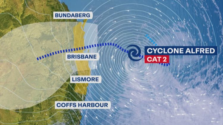
According to modeling, the category two system, located roughly 630 kilometers east of Brisbane, will begin moving toward the coast later this week before making landfall between Brisbane city council and the Sunshine Coast.
According to senior forecaster Jonathan How of the Bureau of Meteorology, the most recent models indicate that the cyclone is "probably more likely" to pass across Brisbane's northern suburbs.
Alfred is predicted to reach landfall at category 2 strength late Thursday or early Friday morning, though its intensity may change over the next few days.
It will be the first time the south-east has been in the direct firing line of a tropical cyclone in several decades.
Statements:
Mr How said the location of landfall "will be very critical" because the worst impacts will be felt on the southern side of the system.
"We are expecting to see pretty broadly 200 to 400 millimetres [of rain] … but we could even see isolated falls of 500 to 700mm, particularly in areas from the Gold Coast down towards the Northern Rivers," he said.
"That includes places like Lismore, Mullumbimby, down towards Cape Byron and also inland parts of the Northern Rivers as well."
Heavy rainfall and gales with destructive wind gusts of up to 120 km/h are predicted for portions of northeastern New South Wales and south-east Queensland like Bundaberg, Sunshine Coast starting tomorrow.
The crisis coordination team has been alerted by the National Emergency Management Agency (NEMA), and a multipurpose heavy-lift helicopter is scheduled to arrive today close to the Queensland-NSW border.
In preparation for increasing conditions, generators and medical personnel have been sent to vulnerable island settlements, flood rescue teams are on standby, and sandbagging facilities are open.
"It's not unprecedented, but it's unusual to have a cyclone of this severity crossing the coast," Queensland Premier David Crisafulli said.
"But I've seen the way the south-east Queensland Government has handled flooding in the past, this just has an added layer of complexity."
Storm Surges Posing 'Significant Concern' as Cyclone Approaches
With waves exceeding 7 meters recorded overnight near North Stradbroke Island, authorities are cautioning that storm surges might raise the risk of flooding in low-lying coastal regions.
Storm surges could affect locations like Golden Beach and Noosa on the Sunshine Coast and canal properties on the Gold Coast, according to Mr. Crisafulli, if the weather system crosses during high tide.
Tropical Cyclone Alfred "may be the most significant system since 1954," according to Gold Coast Acting Mayor Donna Gates, with the hinterland potentially receiving up to one meter of rain.
She said a crossing north of the city would cause major issues.
"That's the worst possible scenario for us, because we'll get all the damaging winds coming off the southern tail of the cyclone."
40 rescue teams were on standby in case of a flood tragedy in the Northern Rivers region, according to NSW Premier Chris Minns.
Massive swells and strong gusts of up to 100 kph are predicted for beaches in the northern part of the state.
"Then lastly rain, and obviously those communities have gone through massive amounts of flooding in recent years," Mr Minns said.
"This is the last thing that they want to hear, but we’re asking them to be prepared, to listen to community awareness messages from the SES, and be prepared for the worst."
Campuses Closed and Ferry Services Suspended Due to Cyclone Warnings and Impact
Before Alfred approaches the coast, island residents under threat have been invited to decide whether to stay or flee.
"Many of those people on the islands, that decision either has been taken away from them or that window will close shortly," Mr Crisafulli said.
"Once you make a decision to go or to stay, we will support you through that."
In Queensland, public, Catholic, and independent schools are all still open today. Information regarding state school closures for the following day will be provided every afternoon.
This week, the campuses of Australian Catholic University and Queensland University of Technology will also close.
"We'll continue to operate health services for as long as it's safe to do so, but again, we'll be getting out that messaging," Mr Crisafulli said.
Beginning today and lasting until further notice, CityCat ferries and shipping operations at Mooloolaba on the Sunshine Coast will be discontinued.
Dangers Persist After Cyclone Makes Landfall
Widespread rainfall is expected to continue into next week, extending into eastern NSW and "even as inland as Dubbo and down towards the Riverina", Mr. How said.
"For Queensland, we could see the showers and storms extending into the Darling Downs … it really only clears the coast with a cold front and low-pressure system moving through Victoria on Monday and into Tuesday," he said.
Authorities warn that the threats "won't be over just after it crosses" and that thunderstorms may also occur after the cyclone lands.
"We will continue to see very heavy rainfall right through the weekend," Mr. How said.
"In some areas ... a lot of tropical moisture is making its way into the coast and that will trigger a lot of rain and storms for areas far away from the tropical cyclone itself."
Source
abc.net.au